Carte et territoire / évolution et mutations
The central concern of this book is the history of territory. […] The historical development of cartography has played a major role in this narrative. […] But more to the point, the goal of this book is to understand a new kind of infrastructure – one that is successful exactly because it transcends the military or diplomatic strategy of any individual state.
L’évolution de la cartographie et la nouvelle conception du territoire au 20e siècle sont présentées dans After the Map, un livre novateur publié par William Rankin aux Presses de l’Université de Chicago.
Introduction
Le passage de l’espace national/international à l’espace global/régional correspond à une réorganisation du savoir favorisant de nouvelles façons d’intervenir et de régir. Le point de vue de l’auteur sur cette mutation géo-épistémologique et sa méthodologie sont expliqués dans l’introduction (vingt pages).
Chapitres
Le livre compte six chapitres axés sur trois projets internationaux.
[ I ] Cartographie / The International Map of the World (IMW)
1 - The Authority of Representation: A Single Map for All Countries, 1891–1939
2 - Maps as Tools: Globalism, Regionalism, and the Erosion of Universal Cartography, 1940–1965
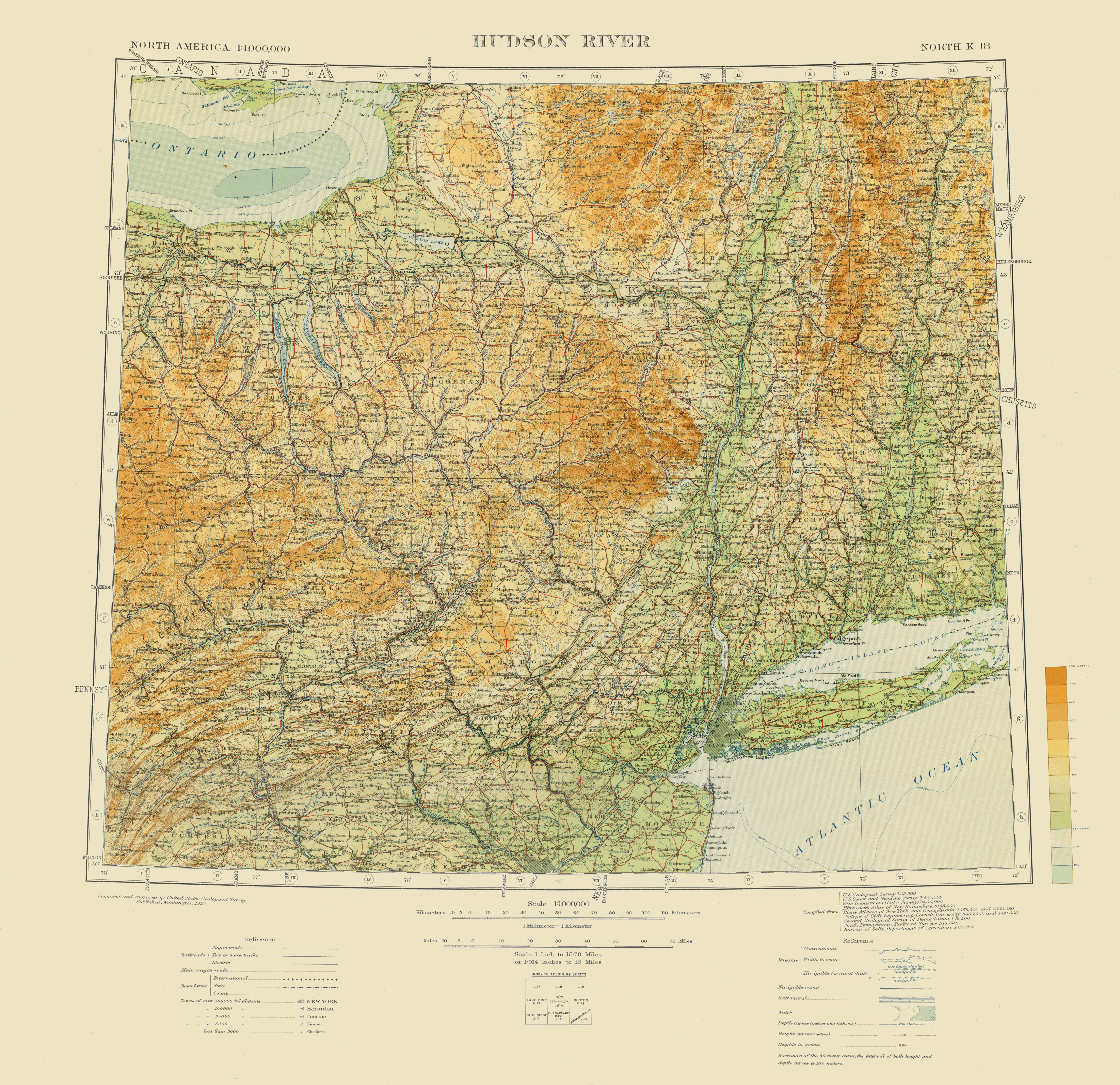
Exemple (extrait): carte du lac George (1927)

[ II ] Géodésie / The Universal Transverse Mercator System (UTM)
3 - Aiming Guns, Recording Land, and Stitching Map to Territory: The Invention of Cartographic Grid Systems, 1914–1939
4 - Territoriality Without Borders: Global Grids and the Universal Transverse Mercator, 1940–1965
Exemple (extrait): carte de la rivière Patuxent (1987)

[ III ] Navigation / The Global Positioning System (GPS)
5 - Inhabiting the Grid: Radionavigation and Electronic Coordinates, 1920–1965
6 - The Politics of Global Coverage: The Navy, NASA, and GPS, 1960–2010
Exemple: carte du réseau Internet (2009)
[Document cartographique supprimé sur le site]
Conclusion, compléments et appréciation
Dans sa conclusion, l’auteur rappelle deux caractéristiques de la nouvelle cartographie née au cours du siècle dernier: «Together the IMW, UTM, and GPS tell a relatively coherent strory about globalism and the mapping sciences in the twentieth century. […] At a more straightforward level, this has also been a story about a transition from international scientific collaboration to American military technology.»
Les remerciements, la liste des acronymes, la liste des illustrations en couleurs, les notes et l’index complètent l’ouvrage. Par ailleurs, la bibliographie (auteurs, dates) et les illustrations (en haute résolution) peuvent être consultées et téléchargées depuis le site éponyme du livre.
Le contenu du livre est très bien structuré. Les enjeux sont clairement expliqués. Les explications sont limpides. Le style de l’auteur est dynamique. Les nombreuses cartes sont légendées et plusieurs d’entre elles sont reproduites en couleurs dans un cahier inséré au milieu du livre.
Références
Rankin, William. - After the Map. Cartography, Navigation, and the Transformation of Territory in the Twentieth Century. - Chicago: University of Chicago Press, 2016. - viii, 398p. - ISBN 978-0-226-33936-8. - [Citations, p. 5, 6, 5; 295; 298]. - Diplômé des universités Harvard et Race, l’auteur enseigne l’histoire des sciences à l’Université Yale. - BAnQ: 526.0904 R2116a 2016.
After the Map (William Rankin)
Radical Geography (William Rankin)
Cartes
Lake George (International Map of the World, 1927) (USGS) (Gouvernement des États-Unis d’Amérique) [Chapitre 1, p. 24]
Patuxent River (Map of Coastal Maryland, 1987) (USGS) (Gouvernement des États-Unis d’Amérique) [Chapitre 3, p. 122]
Global Internet Map 2009 (TeleGeography) [Introduction, p. 12] [Document cartographique supprimé sur le site]
Sur la Toile
La Carte internationale du monde au millionième (Paul Vidal de la Blache, Annales de géographie, 1910)
La Carte internationale du monde au millionième et la Conférence de Paris de 1913 (Emmanuel de Margerie, Annales de géographie, 1914)
La genèse de la Commission de la Carte géologique du Monde (Philippe Bouysse, Comité français d’histoire de la géologie, 2012)
L’introuvable «carte du monde au millionième» (Joëlle Kuntz, Le Temps, 2013)
International Map of the World 1:1,000,000 (Perry-Castañeda Library, The University of Texas at Austin)
Index diagram of sheets for the International map on the scale of 1:1,000,000 (Norman B. Leventhal Map Center)

Aucun commentaire:
Publier un commentaire